 https://basemap.at/wp-content/uploads/sites/53/2019/06/schum1.jpg
326
326
OWeinberger
https://basemap.at/wp-content/uploads/sites/53/2019/06/logo-basemap-trans-3-e1561616417483.png
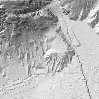
OWeinberger2021-02-01 12:37:112021-06-17 15:30:20GELAENDE
https://basemap.at/wp-content/uploads/sites/53/2019/06/schum1.jpg
326
326
OWeinberger
https://basemap.at/wp-content/uploads/sites/53/2019/06/logo-basemap-trans-3-e1561616417483.png
OWeinberger2021-02-01 12:37:112021-06-17 15:30:20GELAENDE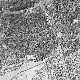 https://basemap.at/wp-content/uploads/sites/53/2019/06/schum2.jpg
326
326
OWeinberger
https://basemap.at/wp-content/uploads/sites/53/2019/06/logo-basemap-trans-3-e1561616417483.png
OWeinberger2021-02-01 12:35:152021-02-15 17:28:05OBERFLAECHE
https://basemap.at/wp-content/uploads/sites/53/2019/06/schum2.jpg
326
326
OWeinberger
https://basemap.at/wp-content/uploads/sites/53/2019/06/logo-basemap-trans-3-e1561616417483.png
OWeinberger2021-02-01 12:35:152021-02-15 17:28:05OBERFLAECHE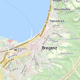 https://basemap.at/wp-content/uploads/sites/53/2021/05/basemap_100.jpg
326
326
OWeinberger
https://basemap.at/wp-content/uploads/sites/53/2019/06/logo-basemap-trans-3-e1561616417483.png
OWeinberger2019-07-31 14:30:552021-06-17 15:29:43STANDARD
https://basemap.at/wp-content/uploads/sites/53/2021/05/basemap_100.jpg
326
326
OWeinberger
https://basemap.at/wp-content/uploads/sites/53/2019/06/logo-basemap-trans-3-e1561616417483.png
OWeinberger2019-07-31 14:30:552021-06-17 15:29:43STANDARD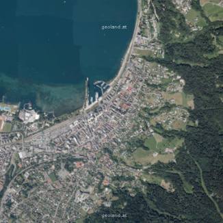 https://basemap.at/wp-content/uploads/sites/53/2021/05/basemap_103.jpg
326
326
OWeinberger
https://basemap.at/wp-content/uploads/sites/53/2019/06/logo-basemap-trans-3-e1561616417483.png
OWeinberger2019-07-31 14:13:312021-06-17 15:31:28ORTHOFOTO
https://basemap.at/wp-content/uploads/sites/53/2021/05/basemap_103.jpg
326
326
OWeinberger
https://basemap.at/wp-content/uploads/sites/53/2019/06/logo-basemap-trans-3-e1561616417483.png
OWeinberger2019-07-31 14:12:132023-03-31 07:24:59ORTHOFOTO
https://basemap.at/wp-content/uploads/sites/53/2021/05/basemap_103.jpg
326
326
OWeinberger
https://basemap.at/wp-content/uploads/sites/53/2019/06/logo-basemap-trans-3-e1561616417483.png
OWeinberger2019-07-31 14:13:312021-06-17 15:31:28ORTHOFOTO
https://basemap.at/wp-content/uploads/sites/53/2021/05/basemap_103.jpg
326
326
OWeinberger
https://basemap.at/wp-content/uploads/sites/53/2019/06/logo-basemap-trans-3-e1561616417483.png
OWeinberger2019-07-31 14:12:132023-03-31 07:24:59ORTHOFOTO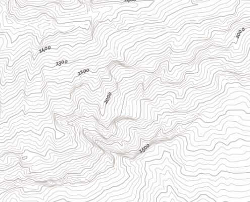 https://basemap.at/wp-content/uploads/sites/53/2019/07/vtch.png
530
530
OWeinberger
https://basemap.at/wp-content/uploads/sites/53/2019/06/logo-basemap-trans-3-e1561616417483.png
OWeinberger2019-07-31 14:04:282021-06-17 15:33:03BMAPVHL
https://basemap.at/wp-content/uploads/sites/53/2019/07/vtch.png
530
530
OWeinberger
https://basemap.at/wp-content/uploads/sites/53/2019/06/logo-basemap-trans-3-e1561616417483.png
OWeinberger2019-07-31 14:03:282023-03-31 07:25:48BMAPVHL
https://basemap.at/wp-content/uploads/sites/53/2019/07/vtch.png
530
530
OWeinberger
https://basemap.at/wp-content/uploads/sites/53/2019/06/logo-basemap-trans-3-e1561616417483.png
OWeinberger2019-07-31 14:04:282021-06-17 15:33:03BMAPVHL
https://basemap.at/wp-content/uploads/sites/53/2019/07/vtch.png
530
530
OWeinberger
https://basemap.at/wp-content/uploads/sites/53/2019/06/logo-basemap-trans-3-e1561616417483.png
OWeinberger2019-07-31 14:03:282023-03-31 07:25:48BMAPVHL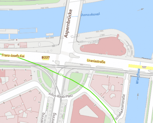 https://basemap.at/wp-content/uploads/sites/53/2019/07/vtc.png
530
530
OWeinberger
https://basemap.at/wp-content/uploads/sites/53/2019/06/logo-basemap-trans-3-e1561616417483.png
OWeinberger2019-07-31 14:01:512021-06-17 15:34:05BMAPV
https://basemap.at/wp-content/uploads/sites/53/2019/07/vtc.png
530
530
OWeinberger
https://basemap.at/wp-content/uploads/sites/53/2019/06/logo-basemap-trans-3-e1561616417483.png
OWeinberger2019-07-31 14:00:292021-06-17 15:34:36BMAPV
https://basemap.at/wp-content/uploads/sites/53/2019/07/vtc.png
530
530
OWeinberger
https://basemap.at/wp-content/uploads/sites/53/2019/06/logo-basemap-trans-3-e1561616417483.png
OWeinberger2019-07-31 14:01:512021-06-17 15:34:05BMAPV
https://basemap.at/wp-content/uploads/sites/53/2019/07/vtc.png
530
530
OWeinberger
https://basemap.at/wp-content/uploads/sites/53/2019/06/logo-basemap-trans-3-e1561616417483.png
OWeinberger2019-07-31 14:00:292021-06-17 15:34:36BMAPV https://basemap.at/wp-content/uploads/sites/53/2019/06/verd1.png
326
326
OWeinberger
https://basemap.at/wp-content/uploads/sites/53/2019/06/logo-basemap-trans-3-e1561616417483.png
OWeinberger2019-07-31 13:50:542021-06-17 15:35:17BASEMAPVERDOGD
https://basemap.at/wp-content/uploads/sites/53/2019/06/verd1.png
326
326
OWeinberger
https://basemap.at/wp-content/uploads/sites/53/2019/06/logo-basemap-trans-3-e1561616417483.png
OWeinberger2019-07-31 13:50:542021-06-17 15:35:17BASEMAPVERDOGD